It’s true. God (at least the Christian one, as Jesus) said so Himself:
“But let your communication be, Yea, yea; Nay, nay: for whatsoever is more than these cometh of evil.”
(Matthew 5:37, King James Version)
It’s true. God (at least the Christian one, as Jesus) said so Himself:
“But let your communication be, Yea, yea; Nay, nay: for whatsoever is more than these cometh of evil.”
(Matthew 5:37, King James Version)
I’m in the process of organizing and backing up the rather large directory structure on my desktop box, in preparation to try out Windows 7 and Ubuntu Linux.
Until I finally buy a BD-R drive (which will probably happen sometime this year), this means backing up to DVD-R discs. My mail spool is no problem at 2.3GB or thereabouts, but the \docs directory is another story entirely. There is content in there — probably large, unused content — from at least as far back as the first Clinton administration. I don’t mind keeping old data around if it’s reasonably sized, but how to tell where the disk-hogging directories are?
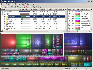
Googling “directory tree size,” I came across WinDirStat. It’s a freeware application to scan a given directory structure and show how much is taken up by which subdirectories.
It also takes this data and maps it into pretty fractal pictures.

I’ll post my thoughts on Ubuntu and Windows 7 when I get to them. I may even try out the 64-bit version of XP, depending on how much I like or dislike Win7. (With 64-bit support and newer versions of DirectX, I *want* to like it — but I have concerns about the way the GUI has been evolving since Office 2007 and Vista.)
This looks interesting: the US Federal Government has released some 300 data sets to the public via Data.Gov.
They say sunshine is the best disinfectant; making as much data as possible as public as possible sounds like a great idea to me.
I guess it had to happen eventually. The US Coast Guard apparently intends to turn off Loran-C next month.
Just as Loran took over from Omega, GPS is now making Loran-C obsolete. Still, we dinosaurs will miss it. Loran has long been associated with marine and aircraft navigation, of course, but it also has a special place in my heart as the first navigation technology that I used.
Back in the day (mid ’90s?), I found a surplus Loran-C receiver at a hamfest. I didn’t really know how they worked at the time, but it was cheap ($10 or $20, I think), and it came with a book that explained what voltage and polarity it needed on the power connector, so I bought it.
After a little reading, some soldering, and some programming in TRS-80 Model 100 BASIC (an awesome little laptop — more about it later), I actually had a functional navigation system! That is, I could tell my latitude and longitude, and calculate line-of-sight distance to various waypoints that I set. Not the most practical thing in the world to mount in a car, but it was a lot of fun.
It actually did help with navigation, too. A few days after installing it, I was driving home from a friend’s house in Norfolk, and turned the wrong way onto Tidewater Drive. I’d have found this out soon enough myself, but I happened to glance down at the Loran, saw that my heading was 360ish when it should have been 180ish, and did a U-turn. That was pretty cool — I never expected it to actually do something practical.
I got a lot of programming experience out of it, too. The Loran would output its latitude and longitude (in degrees, minutes, and seconds) once a second. Even compressed into bytes, this was three bytes for latitude and three for longitude, every second. Today, this is a ridiculously low data rate — but on a Model 100 laptop with a whole 22k of free memory (including the logger program code), six bytes a second was WAY too much for logging a long trip — it wouldn’t even last an hour.
So I got creative. I realized that the latitude and longitude *degrees* hardly ever changed — and that the minutes didn’t change much, either. I came up with a scheme to compress the data: two bytes were normally recorded each second for the latitude and longitude, except when one or the other rolled over to the next minute and/or degree. In those cases, an “!” was inserted in the data, telling the plotting program that a full six-byte frame would follow.
With that scheme, I was able to record over eight hours’ worth of data in the M100’s 22k of memory — including the recording/compression program! My friend Jason and I took the whole setup (ported to a larger Compaq Plus computer) along on a road trip to Milwaukee and back. It worked pretty well — even when we had to shift it over onto the Great Lakes Loran chain.
I don’t know how good its accuracy (repeatability) was, but its precision was sometimes pretty good. On the way back from one roadtrip, I decided to drive all the way around a cloverleaf interchange (four 270-degree turns) as a test. When I got back home and looked at the data using a quick-and-dirty plotting program I wrote, the whole cloverleaf was clearly visible, albeit squashed a bit in places due to only having one update every six seconds. Not bad for several-decades-old technology.
I know it had to go — but I’m still going to miss it.